
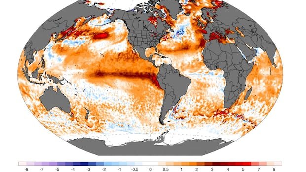

The highly anticipated El Niño has arrived and is already meeting expectations. Earlier this year, climate experts predicted the development of an El Niño in the central Pacific region. Over time, models increasingly indicated a potentially strong or “super” El Niño, though it was cautioned that certainty was premature.
In June, the U.S. National Oceanic and Atmospheric Administration (NOAA) confirmed the presence of warmer conditions in the specific Niño 3.4 region of the Pacific Ocean, necessary for an El Niño classification. Current ocean temperatures in this zone are nearly 2 degrees Celsius above average, setting a record for this time of year.
Notably, climate scientist Zeke Hausfather mentioned that temperatures in the traditional Nino 3.4 region have surpassed 2 degrees Celsius, indicating conditions bordering on a very strong or “super” El Niño, even in early July.
El Niño and La Niña are part of the larger El Niño Southern Oscillation (ENSO) cycle, affecting the Pacific Ocean. La Niña brings cooler temperatures while El Niño brings warmth. Forecasts suggest the El Niño may peak in October, although many models lean towards a peak in November or December.
Comparing to past El Niño events, the current conditions are unprecedented. The shift from La Niña to El Niño has been swift this year, prompting questions about the underlying causes. Despite some models initially projecting a potential increase of 4 degrees Celsius above average, reaching a peak of around 3.6 degrees Celsius seems increasingly likely.
As for the role of climate change in these extreme conditions, the scientific community is still divided on reaching a consensus. Concerns about the impact of El Niño on food security in tropical regions and potential winter effects in Canada, such as milder temperatures and drier conditions leading to heightened wildfire risks, are growing.
Overall, the severity of this El Niño event underscores the need to prepare for significant impacts across various sectors.