
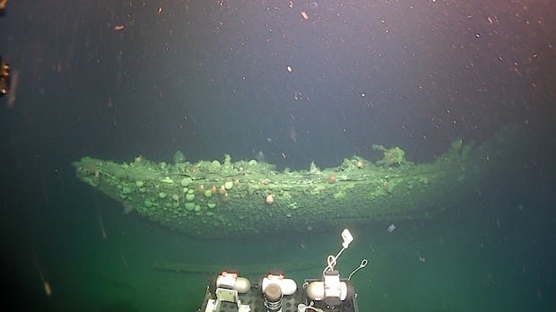

After spending 80 years submerged in the Labrador Sea, the Terra Nova appears vastly altered from its days carrying renowned British explorer Robert Falcon Scott to the South Pole. Described as a wreck in poor condition but intriguing nonetheless, David Mearns, the co-chief scientist of the Canadian-led expedition, made these observations. The ship was initially located in 2012 off the coast of Greenland, with the current mission marking the first scientific endeavor to capture detailed imagery of the vessel.
The research team, aboard the vessel Atlantis, utilized a remotely operated vehicle (ROV) to map the Terra Nova wreck overnight. The ship, which was launched in 1884 and later embarked on Scott’s final expedition in 1910, now lies at a depth of 170 meters and about 30 kilometers south of Greenland since its sinking in 1943. Notably, the ship’s double wheels, used for steering the 57-meter sail and steam vessel, are clearly visible, along with other components like the rudder, boilers, and steam winches.
Innovative technology developed by Voyis, based in Waterloo, Ontario, is not only capturing images and videos but also generating three-dimensional maps of the entire ship. Marine biologist Kirstin Meyer-Kaiser emphasized the significance of the 3D model in providing comprehensive context for research purposes, enhancing the quantitative aspects of her studies and preserving a detailed record for future investigations.
Dwight Coleman, the expedition’s other co-chief scientist and director of ocean imaging at the Woods Hole Oceanographic Institution in Massachusetts, praised the advancements in technology over the years. He highlighted the expedition’s focus on meticulously studying northern shipwrecks, bridging crucial gaps in our understanding with the aid of cutting-edge camera systems.
Meyer-Kaiser’s research also delves into the marine life that has colonized the Terra Nova post-abandonment. Acting as a refuge for fish amidst the barren sea floor, the ship attracts a variety of species, notably redfish, creating a vibrant ecosystem around the wreck. She aims to comprehend the implications of human-made objects like shipwrecks on marine environments to predict the impacts of future oceanic activities effectively.
John Geiger, the president of the Royal Canadian Geographical Society leading the expedition, reflected on the significance of exploring the Terra Nova and Quest, the vessel on which Shackleton met his demise. He underscored the historical importance of these ships as pioneering exploration vehicles and the value of documenting their legacies with modern oceanic technology, more than a century after their groundbreaking expeditions.